Conquering the Sea: The Netherlands' Journey from Flood Defense to Economic Prowess
A blue print of how the gamble with climate change will playout
In the intricate world of national management, the Netherlands stands as a beacon of innovation and resilience. This diminutive European nation has transformed its geographical challenges into a showcase of human ingenuity. Let’s delve into why the Netherlands, known for its expansive tulip fields and intricate canal systems, is more than just picturesque landscapes—it’s a masterclass in maritime engineering and land reclamation, particularly in the face of rising sea levels.
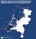
The Netherlands’ relationship with water is a defining characteristic of its existence. Approximately 27% of its land area lies below sea level, and about 60% is vulnerable to flooding. This precarious situation stems from its location in the delta of several major European rivers and its low-lying topography. Historically, the Netherlands faced significant flood risks, necessitating innovative solutions to secure its land and safeguard its population.
Flooding and sea level rise have profoundly influenced Dutch history, shaping its economy, society, and engineering practices. The struggle against water has been a constant theme throughout Dutch history:
The St. Elizabeth’s Flood (1421): One of the most devastating floods in Dutch history occurred in 1421 when the sea breached dykes in the southwest of the Netherlands, inundating large parts of the country. The St. Elizabeth’s Flood caused extensive damage, creating new lakes and permanently altering the landscape. This catastrophe underscored the urgent need for improved flood defenses and laid the groundwork for future engineering endeavors.
The North Sea Flood of 1953: This disaster remains one of the most significant events in Dutch flood history. A powerful storm surge struck the Netherlands, breaching dykes and causing widespread flooding that claimed over 1,800 lives and inundated tens of thousands of homes. In response, the Dutch government launched the ambitious Delta Works project, a comprehensive suite of flood defenses designed to protect the country from future surges. This project not only rebuilt the damaged infrastructure but also set new standards for flood protection worldwide.
The Zuiderzee Works (1920s-1960s): The Zuiderzee Works were a monumental land reclamation project that transformed the Zuiderzee, a large inland sea, into a network of freshwater lakes and reclaimed farmland. Initiated after the devastating floods of 1916, the project involved the construction of dykes and the creation of polders. This massive engineering effort not only increased the country’s usable land but also exemplified the Dutch commitment to controlling water and adapting to environmental challenges.
As the Dutch engineered their defenses against water, they also unwittingly created a fertile ground for the discovery of natural resources. The Groningen gas field, one of the largest natural gas fields in Europe, was discovered in 1959, just a few years after the Delta Works began to take shape. The geological conditions that enabled the formation of natural gas were facilitated by the stability provided by these extensive water management systems. The very infrastructure that protected the land from flooding also enabled the exploration and extraction of valuable energy resources beneath it.
Keep reading with a 7-day free trial
Subscribe to The Monetary Skeptic to keep reading this post and get 7 days of free access to the full post archives.


